02. 2014年5月13日 19:57:23
: jXbiWWJBCA
http://www.nasa.gov/press/2014/may/nasa-uci-study-indicates-loss-of-west-antarctic-glaciers-appears-unstoppable/#.U3H6ufl_u0c
May 12, 2014
RELEASE 14-131
NASA-UCI Study Indicates Loss of West Antarctic Glaciers Appears Unstoppable
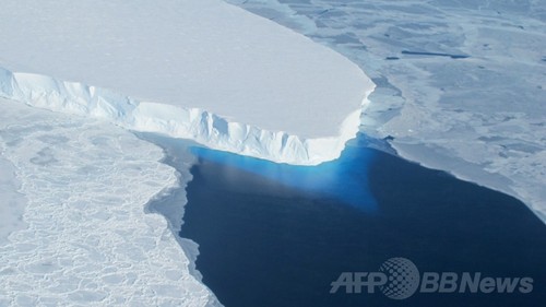
Glacier melt in Antarcticav
Glaciers in West Antarctica’s Amundsen Sea Embayment have “passed the point of no return” according to new research based on three different lines of evidence.
Image Credit: NASA/Eric Rignot
A new study by researchers at NASA and the University of California, Irvine, finds a rapidly melting section of the West Antarctic Ice Sheet appears to be in an irreversible state of decline, with nothing to stop the glaciers in this area from melting into the sea.
The study presents multiple lines of evidence, incorporating 40 years of observations that indicate the glaciers in the Amundsen Sea sector of West Antarctica "have passed the point of no return," according to glaciologist and lead author Eric Rignot, of UC Irvine and NASA's Jet Propulsion Laboratory (JPL) in Pasadena, California. The new study has been accepted for publication in the journal Geophysical Research Letters.
These glaciers already contribute significantly to sea level rise, releasing almost as much ice into the ocean annually as the entire Greenland Ice Sheet. They contain enough ice to raise global sea level by 4 feet (1.2 meters) and are melting faster than most scientists had expected. Rignot said these findings will require an upward revision to current predictions of sea level rise.
"This sector will be a major contributor to sea level rise in the decades and centuries to come," Rignot said. "A conservative estimate is it could take several centuries for all of the ice to flow into the sea."
Three major lines of evidence point to the glaciers' eventual demise: the changes in their flow speeds, how much of each glacier floats on seawater, and the slope of the terrain they are flowing over and its depth below sea level. In a paper in April, Rignot’s research group discussed the steadily increasing flow speeds of these glaciers over the past 40 years. This new study examines the other two lines of evidence.
The glaciers flow out from land to the ocean, with their leading edges afloat on the seawater. The point on a glacier where it first loses contact with land is called the grounding line. Nearly all glacier melt occurs on the underside of the glacier beyond the grounding line, on the section floating on seawater.
Just as a grounded boat can float again on shallow water if it is made lighter, a glacier can float over an area where it used to be grounded if it becomes lighter, which it does by melting or by the thinning effects of the glacier stretching out. The Antarctic glaciers studied by Rignot's group have thinned so much they are now floating above places where they used to sit solidly on land, which means their grounding lines are retreating inland.
"The grounding line is buried under a thousand or more meters of ice, so it is incredibly challenging for a human observer on the ice sheet surface to figure out exactly where the transition is," Rignot said. “This analysis is best done using satellite techniques."
The team used radar observations captured between 1992 and 2011 by the European Earth Remote Sensing (ERS-1 and -2) satellites to map the grounding lines' retreat inland. The satellites use a technique called radar interferometry, which enables scientists to measure very precisely -- within less than a quarter of an inch -- how much Earth's surface is moving. Glaciers move horizontally as they flow downstream, but their floating portions also rise and fall vertically with changes in the tides. Rignot and his team mapped how far inland these vertical motions extend to locate the grounding lines.
The accelerating flow speeds and retreating grounding lines reinforce each other. As glaciers flow faster, they stretch out and thin, which reduces their weight and lifts them farther off the bedrock. As the grounding line retreats and more of the glacier becomes waterborne, there's less resistance underneath, so the flow accelerates.
Slowing or stopping these changes requires pinning points -- bumps or hills rising from the glacier bed that snag the ice from underneath. To locate these points, researchers produced a more accurate map of bed elevation that combines ice velocity data from ERS-1 and -2 and ice thickness data from NASA's Operation IceBridge mission and other airborne campaigns. The results confirm no pinning points are present upstream of the present grounding lines in five of the six glaciers. Only Haynes Glacier has major bedrock obstructions upstream, but it drains a small sector and is retreating as rapidly as the other glaciers.
The bedrock topography is another key to the fate of the ice in this basin. All the glacier beds slope deeper below sea level as they extend farther inland. As the glaciers retreat, they cannot escape the reach of the ocean, and the warm water will keep melting them even more rapidly.
The accelerating flow rates, lack of pinning points and sloping bedrock all point to one conclusion, Rignot said.
"The collapse of this sector of West Antarctica appears to be unstoppable," he said. "The fact that the retreat is happening simultaneously over a large sector suggests it was triggered by a common cause, such as an increase in the amount of ocean heat beneath the floating sections of the glaciers. At this point, the end of this sector appears to be inevitable."
Because of the importance of this part of West Antarctica, NASA's Operation IceBridge will continue to monitor its evolution closely during this year's Antarctica deployment, which begins in October. IceBridge uses a specialized fleet of research aircraft and the most sophisticated suite of science instruments ever assembled to characterize changes in thickness of glaciers, ice sheets and sea ice.
For additional images and video related to this new finding, visit:
http://go.nasa.gov/1m6YZSf
For additional information on the West Antarctic Ice Sheet and its potential contribution to sea level rise, visit:
http://go.nasa.gov/1oIfSlO
For more information on Operation IceBridge, visit:
http://www.nasa.gov/icebridge
The California Institute of Technology in Pasadena manages JPL for NASA.
NASA monitors Earth's vital signs from land, air and space with a fleet of satellites and ambitious airborne and ground-based observation campaigns. NASA develops new ways to observe and study Earth's interconnected natural systems with long-term data records and computer analysis tools to better see how our planet is changing. The agency shares this unique knowledge with the global community and works with institutions in the United States and around the world that contribute to understanding and protecting our home planet.
For more information about NASA's Earth science activities in 2014, visit:
http://www.nasa.gov/earthrightnow
-end-
http://sankei.jp.msn.com/science/news/140513/scn14051311470002-n1.htm
南極の氷床融解「限界点、越えてしまった」 NASA、支え失った氷が浮いた状態
2014.5.13 11:47 [温暖化]
南極西側の海に浮かぶスウェイツ氷河の一部(NASA提供)
南極西側の海に浮かぶスウェイツ氷河の一部(NASA提供)
南極大陸の一部で、温暖化する海の影響により氷床の融解に歯止めがきかなくなり、将来の大幅な海面上昇が避けられそうにないとする研究結果を米航空宇宙局(NASA)などの研究チームが12日、発表した。 NASAの研究者は「南極の氷が将来崩壊せずにすむ限界点を越えてしまった」と警告。国連の気候変動に関する政府間パネル(IPCC)が昨年、世界の平均海面が今世紀末に最大82センチ上昇するとの報告書をまとめたが「上方修正が必要」と指摘している。 NASAのチームはレーダー衛星の観測データを使い南極大陸の西側に位置する氷床の構造変化を分析。その結果、温かい海水が氷床の下に入り込んで氷が解ける現象が加速しており、下の支えを失った氷が海に浮いた状態になって、さらに融解が進む悪循環が起き始めていると指摘した。 米ワシントン大などのチームは同日、少なくとも200〜千年後に巨大氷床が崩壊し大規模な海面上昇が起きるとする予測を、米科学誌サイエンス電子版に発表した。(共同)
温暖化「米社会に打撃」 米が警告色強めた報告書「未来でなく現在の課題」
2014.5.7 10:19 [温暖化]
米ホワイトハウスは6日、地球温暖化による豪雨や洪水、干ばつなどの異常気象が深刻化し、米国社会や経済に打撃を与えているとする「気候変動に関する報告書」を発表した。議会が政府に4年ごとの作成を求めており3回目。各地の被害を示し「遠い将来のものとされてきた気候変動が現在の課題となった」と指摘。温室効果ガスの削減と併せ、海面上昇によるインフラ損失などを防ぐ適応策の必要性を訴えている。
前回報告書より踏み込んだ内容で、オバマ大統領は温暖化対策の行動計画を前進させる狙い。6月には既存の火力発電所が排出する二酸化炭素(CO2)の規制案を発表する予定だが、石炭業界や共和党から激しい反発が予想される。 報告書は人間活動が温暖化を引き起こしていると指摘。米沿岸で今世紀末に最大1・2メートルの海面上昇が起きる危険があるとした。東海岸やメキシコ湾沿岸でハリケーンや豪雨によるインフラ被害の増加を予測。西海岸や内陸部では雨量が減る地域もあるとした。(共同)
「命奪う寒さ」温暖化副作用? 米、記録的な寒波で死者20人超
デング熱 世界に拡大 100カ国超で感染…温暖化影響
IPCC「温暖化阻止、すぐ行動を」 再生エネ投資の拡大促す
温暖化、安全保障にも影響 4度上昇で被害深刻 IPCCが新報告書
【主張】温暖化対策 今は原発を動かすときだ
|
|
03. 2014年5月13日 20:24:06
: Fz9HdhePO6
>>02さんへ英訳文ありがとうございます。 え〜、科学者が大騒ぎをする程には、
庶民はピンと来ないワケですよ。 夏は確かに昔より暑くなったと感じるし、
春や秋も何だかあっという間に過ぎて短いな〜っていう気はする。 しかし、冬は相変わらず寒い、
寒いどころか酷い豪雪だった。 気候モデルが複雑なのも解るし、
30年に一度と言われる異常気象も頻繁に起こっている。 しかし、それが本当に人間活動が主たる原因なのかが怪しいのです。
怪しいままに炭素税を払ったり、
原発再稼働を進められたりが納得いかんのです。 地球は反対に氷河期に向かっているなんて説まで流れれば尚更です。 将来に対する保険です、とか言われてもねぇ…
「温暖化説は間違ってました」で、
それまで支払った炭素税は戻って来ますか?
日本国中が原発100基、200基と乱立していた後だったらどうしますか? 科学者の警告だけでは庶民には馬耳東風だと思います。
|
|

 スパムメールの中から見つけ出すためにメールのタイトルには必ず「阿修羅さんへ」と記述してください。